

Please prepare spiritually for the next 4 to 5 years will be a wild ride (we think). This prediction is already coming to pass. Mississippi River is already “drying up” losing water mass. But it’s not all evaporation as they say. It’s going underground to later rise a couple hundred miles to the East.. To be more aligned with the Great Lakes. Which was probably where it should have been anyway. Levys and Dams are a desecration of God’s waterways. And now He is repairing this Earth. The New Earth is coming. But disasters will ensue. Desperate times desperate measures. See bottom article for the beginning of confirmation.
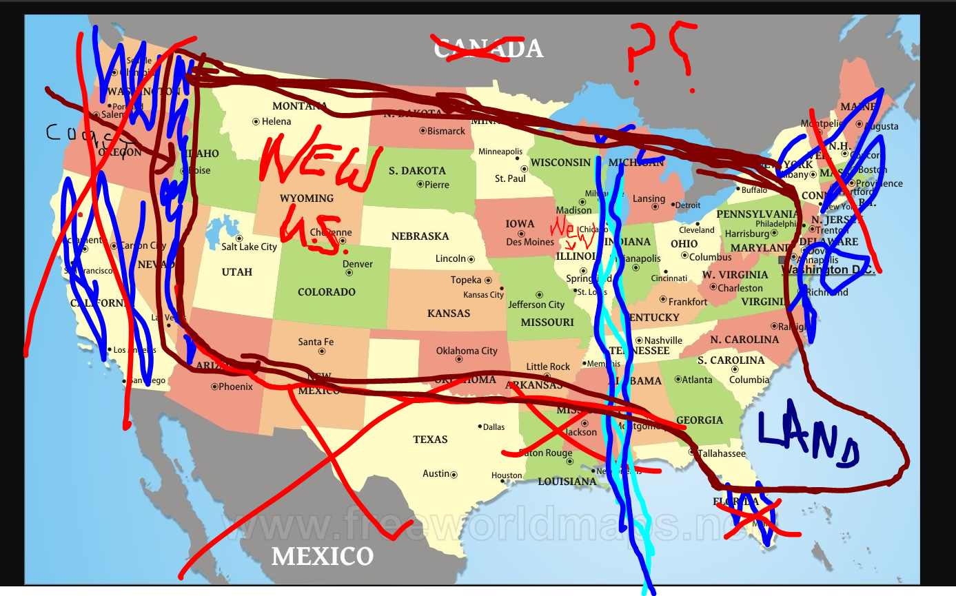
This is an approximate. I am going by memory of a vision. I must also add that Florida was somehow further North than shown. Therefore the southern, NEW coastline may actually be about 70 Miles lower 1/2 way into Texas and parallel. But to get the Florida coast right and to get the shape correct…I could not move Florida, Texas, Mississippi, Alabama and so on further north as they appeared in my vision.
Update 2025 Cracks discovered on the grounding floor of the Mississippi River Bed showing signs that this prediction is on the way in. See More
“The phrase “Transpressive stress NMSZ cracks in the floor of the Mississippi New Madrid Fault” describes a complex geological phenomenon occurring in the New Madrid Seismic Zone (NMSZ). Let’s break down the key terms and concepts:
Transpressive Stress: This refers to a type of tectonic stress where the ground is being squeezed together (compression) while also sliding past each other (strike-slip). Imagine trying to slide two blocks of wood past each other, but also pushing them inwards simultaneously. This combination of forces is called transpression.
NMSZ (New Madrid Seismic Zone): This is a region in the central United States, encompassing parts of Missouri, Arkansas, Tennessee, Kentucky, and Illinois, known for being seismically active. The NMSZ is the most active seismic area in the United States east of the Rocky Mountains.
“Cracks in the floor of the Mississippi New Madrid Fault”: This likely refers to fissures and other surface ruptures formed during earthquakes within the NMSZ. The NMSZ faults themselves are buried deep beneath layers of river sediment, so they don’t have visible traces at the surface like some faults in other regions. However, strong shaking during earthquakes can cause significant ground deformation, including:
Fissures: Long, narrow openings in the ground.
Sand Blows: Cones of sand ejected from the ground, caused by liquefaction. Liquefaction occurs when saturated soil loses its strength during an earthquake and behaves like a liquid, forcing sand and water to the surface.
In summary, the phrase you provided describes the formation of surface cracks and fissures, potentially including sand blows and liquefaction features, caused by earthquakes that result from transpressional stress within the New Madrid Seismic Zone located in the central United States, within the Mississippi River valley area.
It’s important to note that the NMSZ is a complex area, and while there’s ongoing research to understand its seismic behavior, it poses a significant hazard due to the potential for large earthquakes and widespread damage.”
2019 June 23 Article Original Article
The Florida coastline will be just north of New Tampa so Wesley Chapel and Darby are inland. Everything south of North New Tampa will be under water. Tampa is a cesspool of debauchery its not wonder it will be cleansed by water.
All land south of this new coastline including South America and all parallel lands where under water. But as you can see east of Florida rose up and was given new land which is odd. Illinois will be called NEW ILLINOIS. I saw that clearly. California, gone, seems like Canada was gone too but I am really not certain of this. I do not know but clearly the U.S. was no longer attached to Canada. I could be wrong.
NEW INFORMATION 2025 Possible Soon Fulfillment of this 2019 Original Prediction
UPDATED PREDICTION CONFIRMING INFO ABOUT MISSISSIPPI RIVER SPLITING ITS GROUND BELOW.
The ground beneath the Mississippi River Delta is indeed subsiding (sinking) and eroding at alarming rates, losing land to the Gulf of Mexico due to a combination of natural sinking, human-built levees starving the delta of sediment, sea-level rise, and increased saltwater intrusion, creating wetlands loss that threatens coastal communities and ecosystems. This process is accelerated by reduced sediment supply, allowing the land to sink and be washed away, with significant portions of Louisiana vanishing over recent decades.
Key Causes of Land Loss:
Subsidence: The natural sinking of the delta’s land, exacerbated by compaction and the Michoud fault in New Orleans.
Sediment Starvation: Levees built for flood control prevent nutrient-rich sediment from reaching the delta, stopping it from rebuilding itself as it naturally sinks.
Sea-Level Rise: Global sea-level rise adds to the challenge, increasing coastal erosion.
Saltwater Intrusion: Shipping channels allow saltwater to penetrate wetlands, killing vegetation and accelerating erosion.
The Alarming Impact:
Louisiana has lost over 2,000 square miles of land since the 1930s.
Wetlands disappear at a rate equivalent to a football field every 100 minutes in some areas, threatening fisheries, wildlife, and cultural heritage.
Efforts to Combat Loss:
Projects like the Mid-Barataria Sediment Diversion aim to redirect river water and sediment to rebuild land, but face delays.
There’s a significant push for continued investment in coastal restoration to preserve the region’s economy and safety.
In essence, the river system is struggling to keep up with its own sinking and the rising sea, leading to alarming land loss in the Mississippi Delta region.
DAMS AND LEVEE’S REPORT CARD FROM https://infrastructurereportcard.org/cat-item/dams-infrastructure/
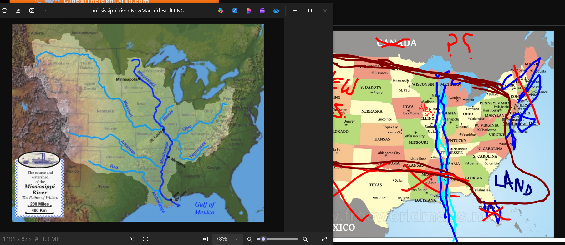
Notice the Mississippi river is in Minnesota and ends up in around Louisiana. The new prediction map shows it starting right under the Great Lakes and moving straight down to the gulf through Mississippi and Alabama. Adding a second Mississippi river several hundred miles to the East. Or what would be more devastating is if it combines with the existing Mississippi River and washes out all the land in between.
BEFORE AFTER
The Mississippi River is losing significant water mass primarily due to extreme, climate-change-driven flash droughts, excessive heat increasing evaporation, and reduced upstream precipitation. Combined with infrastructure altering flow, these factors caused record-low water levels, allowing saltwater to intrude from the Gulf of Mexico.
Drought.gov
Drought.gov
Key Reasons for Water Loss:
Flash Droughts and Heat: Rapid-onset droughts in the Mississippi River Valley and its tributaries (Ohio, Missouri rivers) have led to severely low water levels. High temperatures increase evaporation rates, further depleting the river’s volume.
Reduced Upstream Flow: Over 90% of the water in the Lower Mississippi comes from upstream, so lack of rain in the Midwest directly causes dramatic drops in the lower basin.
Climate Change Alteration: Changing precipitation patterns have made droughts more intense and frequent.
Infrastructure Management: Levees and dams, while designed for flood control, sometimes restrict natural water flow and intensify the impact of low-water events.
Channel Diversion (Deltaic): In the lower delta, breaches like Neptune Pass are diverting significant percentages of the river’s flow into new paths.
Drought.gov
Drought.gov
Consequences of Reduced Water Mass:
Saltwater Intrusion: The reduced volume allows Gulf of Mexico saltwater to creep up the river, threatening drinking water in Louisiana.
Navigation Hazards: Low water levels restrict barge traffic and commercial navigation, disrupting vital economic activity.
Habitat Loss: Reduced flow and lowered water tables affect biodiversity, particularly in the wetlands of the Mississippi River Delta
One Reply to “New U.S. Land Mass after the Coming Wrath of God Event”